

After more than three centuries since its disappearance, Sak-Bahlán, the last known city of the Lacandoni-ch’olti’es (an ancient ethnic group of the Maya civilization), may have finally been located. The archaeological site identified in the Montes Azules Biosphere Reserve in Chiapas (southern Mexico) is believed by an international team of scholars to be the possible land of the white jaguar, the last bastion of the rebellious Maya in southern Mexico.
The project, officially registered as Sun and Paradise. Probably Sak-Bahlán, is co-directed by archaeologists Brent Woodfill (Winthrop University, United States) and Yuko Shiratori (Rissho University, Japan), with support from the Archaeology Council of the National Institute of Anthropology and History (INAH) of Mexico. Crucial was the contribution of researcher Josuhé Lozada Toledo of the INAH Chiapas Center, who led the operations through the development of an advanced GIS (Geographic Information System)-based predictive model.
“I took data from the chronicle of Friar De Rivas from 1698; for example, he relates that, that year, he and a troop of soldiers set out from Our Lady of Sorrows (formerly Sak-Bahlán) and walked four days to the Lacantún River,” Toledo explains. “They sailed for two days and arrived at El encuentro de Cristo, a place where the tributary joins the Pasión River, and left their canoes and then walked to Lake Petén Itzá in Guatemala. From those mentioned places, which I had georeferenced, I did a four-day conversion from somewhere on the Lacantún River to Sak-Bahlán. Putting all these variables together, I was able to make the proposal on the map and get a rough range of where the Sak-Bahlán site might be. It’s the heaviest cross-country tour I’ve ever done in my life, but, in the end, we found the archaeological evidence, right at the spot I had marked.”
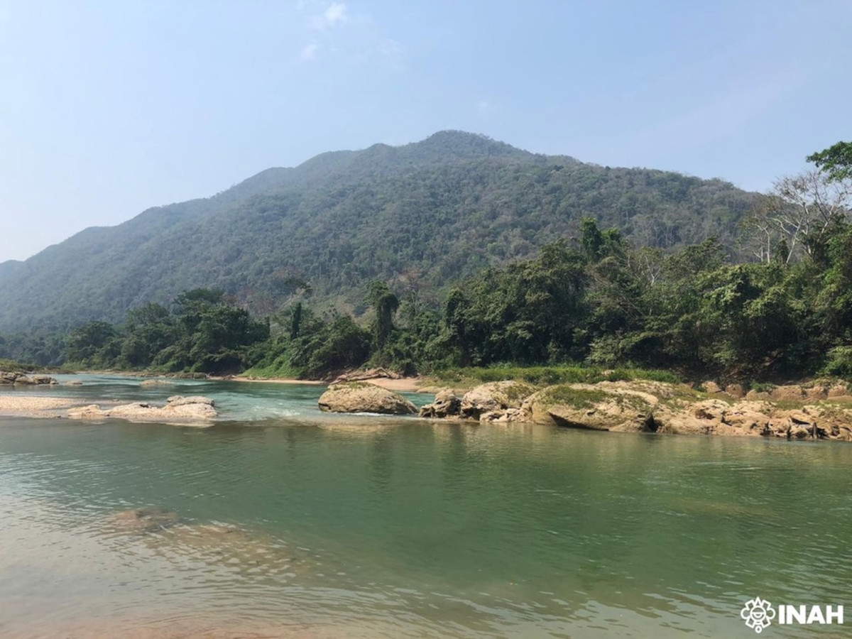
Lozada devised a complex location system from historical sources and a variety of geospatial data. Using ArcGIS Pro software, he overlaid several layers of information, including elevation, vegetation, presence of water bodies and pre-Hispanic communication routes, even taking into account the average weight carried per person. Such an approach made it possible to identify an area compatible with the seventeenth-century descriptions of Sak-Bahlán: a plain enclosed by a bend in the Lacantún River, as reported in the letter of Friar Diego de Rivas in 1695.
To each world, Sak-Bahlán’s existence is documented in colonial archives. It was first sighted by missionary Pedro de la Concepción in the same year, during campaigns to subdue the last independent Maya groups. After its conquest, the settlement was renamed Our Lady of Sorrows, but it was abandoned as early as 1721, swallowed by the dense Chiapas jungle. The Lacandoni-ch’olti’es resisted there for more than a century, beginning in 1586, the year of the fall of their capital Lacam-Tún, also known as Gran Peñón.
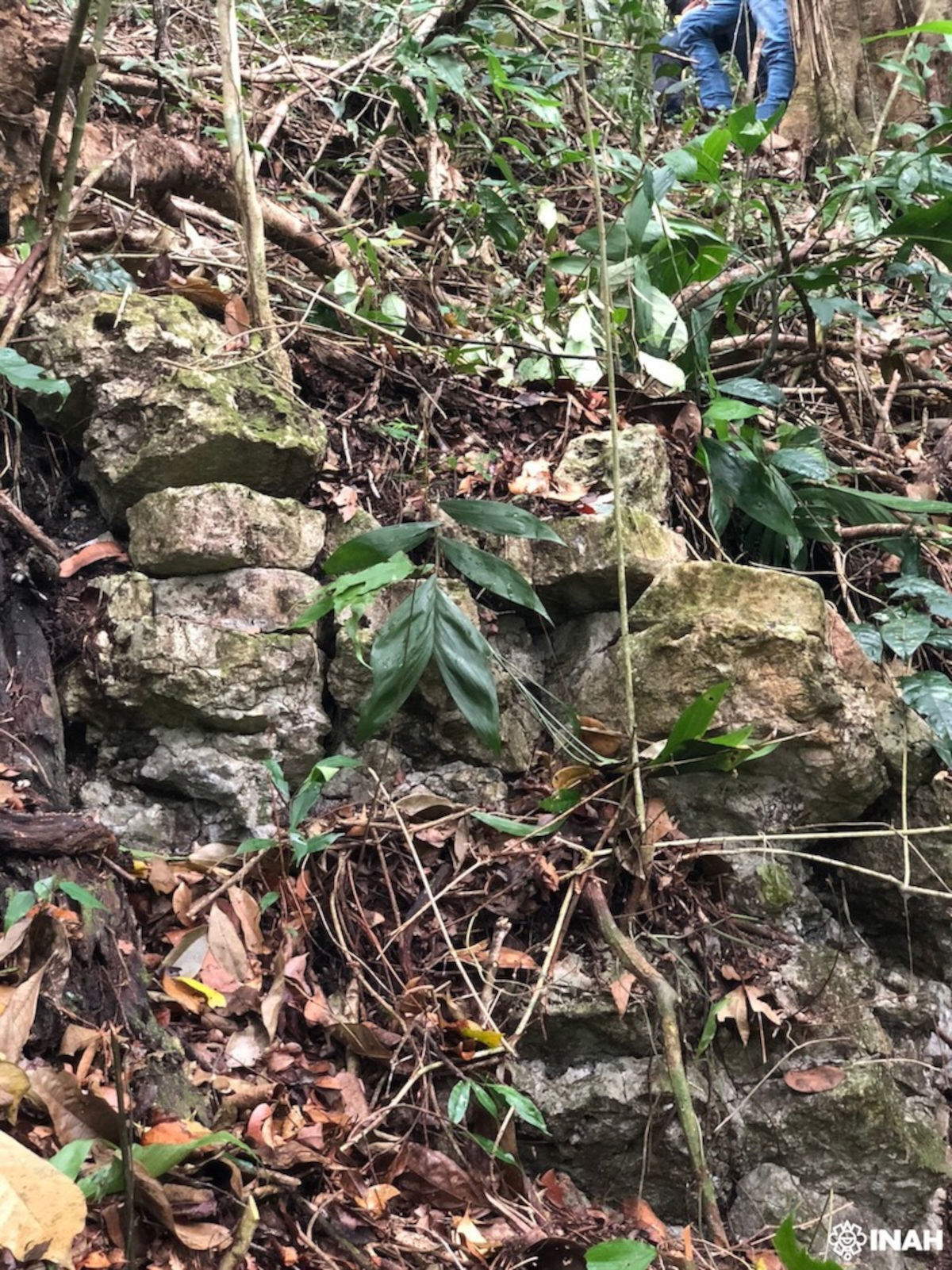
The archaeological project, also supported by the Discovery Channel, has so far carried out two field exploration campaigns. Archaeologists Rubén Núñez Ocampo and Socorro del Pilar Jiménez Álvarez, along with Lozada, have mapped the area and drilled several boreholes to establish the chronology of occupation. The location of the site, near the Jataté and Ixcán rivers, suggests a settlement context compatible with historical colonial sources. The work will be featured in the next issue of the scientific journal Chicomoztoc and also forms the narrative focus of the documentary Discovering the hidden Mayan city: Sac Balam, which chronicles the expedition and its historical implications. For Lozada, the field experience recalled the sense of adventure of nineteenth-century expeditions, but with the advantage of contemporary technology, such as satellite connection.
In truth, the site had proved elusive before. In 1999, an expedition organized by the NGO Conservación Internacional, in which historian Jan de Vos also took part, failed to locate it. De Vos, author of the essay La paz de Dios y del rey (1988), described the Spanish countryside as a process of ethnocide that erased the Lacandan culture. His research thus provided a critical picture of the colonization of the Lacandona Forest, becoming a benchmark for later studies. In 1769 the mayor of Suchitepéquez, Guatemala, initiated a search to locate the vanished village of Dolores, the colonial name assigned to the rebel town. The investigation led him to an abandoned neighborhood of Santa Catarina Retalhuleu, where he located the last three survivors of the tribe, once feared by the indigenous Christians and considered a constant threat by Spanish authorities. The identified site could therefore represent a discovery of great significance for knowledge of the colonial history of Chiapas, and for understanding the cultural persistence of the indigenous groups that opposed Spanish expansion.
 |
| Discovery in Mexico site that may coincide with last Mayan rebel city |
Warning: the translation into English of the original Italian article was created using automatic tools. We undertake to review all articles, but we do not guarantee the total absence of inaccuracies in the translation due to the program. You can find the original by clicking on the ITA button. If you find any mistake,please contact us.
 detto il Pesarese - Galleria Nazionale delle Marche, fino la 12 ottobre")


